svf
svf computes the SVF of a Digital Elevation Model.
SVF stands for Sky View Factor. It is a geophysical parameter that measures the portion of the sky visible from a certain point. The portion of the sky visible above the surface is especially relevant in energy balance studies and computation of diffuse solar insolation.
Sky-view factor is defined as the proportion of visible sky (\(\Omega\)) above a certain observation point as seen from a two-dimensional representation.
The light that falls from the sky onto a certain part of the surface is reduced by the obstacles that form the horizon. These obstacles can be described in all directions by the vertical elevation angle above the horizontal plane.
A good SVF approximation can therefore be performed with the estimate of this angle in several directions. After the vertical elevation angle is determined in the chosen number of directions n, the SVF is determined as a sum of all portions of the sky within each direction: \(\sum \frac {\cos \gamma_i}{n}\), where \(\gamma_i\) is the vertical angle of the horizon in the`direction i.
The angle \(\gamma\) is extracted from the Digital Elevation Model: \(\tan \frac{Height}{Distance}\):
                    _____
                  x|     |  ^
              x    |     |  | Height (from Digital Elevation Model)
         x   __    |     |  |
____p_______|  |___|     |__v____________
    <-------------->
        Distance
Where p is the current pixel where the SVF is computed.
In a direction, the algorithm computes all angles and keeps the largest one. To avoid testing too many points, the “radius” parameter defines the max distance of the pixel to test.
$ georastertools svf --help
usage: georastertools svf [-h] --radius RADIUS --directions DIRECTIONS
                       --resolution RESOLUTION [--altitude ALTITUDE]
                       [-o OUTPUT] [-ws WINDOW_SIZE]
                       [-p {none,edge,maximum,mean,median,minimum,reflect,symmetric,wrap}]
                       inputs [inputs ...]

Compute the Sky View Factor (SVF) of a Digital Elevation Model (DEM).

The Sky View Factor (SVF) is a measure of the visibility of the sky from a
point in a Digital Elevation Model (DEM). It is calculated by evaluating the
horizontal elevation angle from a given point in multiple directions (as
specified by the user), and is influenced by the topography and surrounding
terrain features.

Arguments:

    inputs TEXT

    Input file to process (i.e. geotiff corresponding to a Digital Elevation
    Model). You can provide a single file with extension ".lst" (e.g.
    "svf.lst") that lists the input files to process (one input file
    per line in .lst)

Options:
    --radius INTEGER                Maximum distance (in pixels) around a point
                                    to evaluate horizontal elevation angle
                                    [required]
    --directions INTEGER            Number of directions on which to compute the
                                    horizon elevation angle  [required]
    --resolution FLOAT              Pixel resolution in meter  [required]
    --altitude INTEGER              Reference altitude to use for computing the
                                    SVF. If this option is not specified, SVF is
                                    computed for every point at the altitude of
                                    the point
    -o, --output TEXT               Output directory to store results (by
                                    default current directory)
    -ws, --window_size INTEGER      Size of tiles to distribute processing,
                                    default: 1024
    -p, --pad [none,edge,maximum,mean,median,minimum,reflect,symmetric,wrap]
                                    Pad to use around the image, default : edge(see
                                    https://numpy.org/doc/stable/reference/generated/numpy.pad.html
                                    for more information)
    -h, --help                      Show this message and exit.
Warning
This command line does not accept all input raster products as other raster tools (radioindice, zonalstats). It is mandatory to use a raster file (typically a geotif) in a format that can be read by rasterio: rasterio.open(xxx)).
Example:
Let’s take as input a Digital Elevation Model of Toulouse generated from a PLEIADES stereo (0.5m resolution):
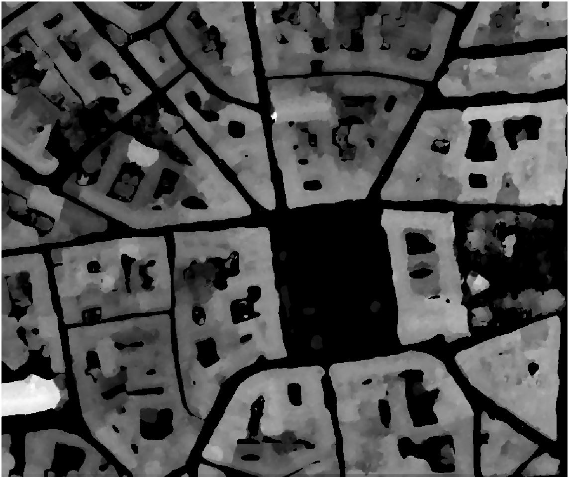
The first command line computes the Sky View Factor using 16 directions and a radius of 50 pixels (25 meters). The SVF is computed at the altitude of every point of the Digital Elevation Model, i.e. the SVF is computed on top of buildings (for the highest building, SVF is thus 1).
$ georastertools svf --radius 50 --directions 16 --resolution 0.5 tests\tests_data\toulouse-mnh.tif
This command generates the following SVF:
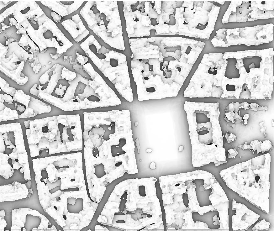
It is also possible to compute the SVF at a specified height, for instance on ground (0m altitude for a Digital Elevation Model).
$ georastertools svf --radius 50 --directions 16 --resolution 0.5 tests\tests_data\toulouse-mnh.tif
The SVF is the following:
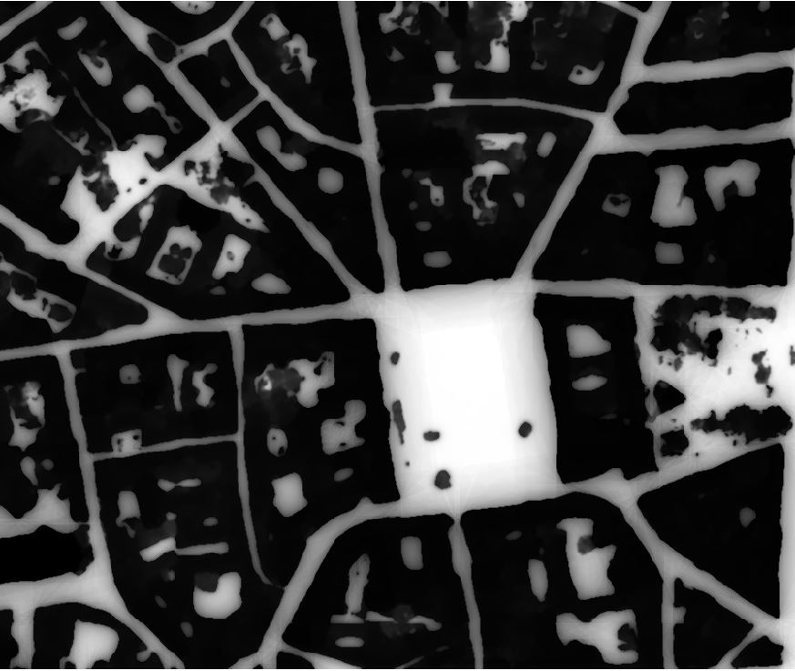
As expected, the SVF at altitude 0m are equal to 0 for pixels inside buildings, and are the same as in the previous image for pixels outside the buildings.